Cemetery
Name
& Link | Map Number | Surveyed in Cemetery Volume # |
Location |
Inactive
(Black) |
|
8 |
Outside of Fence on West Side of
Dresden Cemetery |
|
Akers - Brown
(Inactive) |
|
6 |
Approx, 1/2 mi past Carroll Cemetery North, right of road up in an open
field. |
|
Allen Family Cemetery |
|
|
Richland,
Navarro Co., TX |
|
Alligator Creek |
***
| ***
| see [ Long
Prairie ] |
|
Anderson (Inactive) |
|
7 |
Past Retreat on FM Road 709, 3.2 miles, turn off south and cross site
of Love's Bridge on Richland Creek. Go south 2.5 miles, turn right & go approx. 1/2 mi. On right side in pasture. (3 markers, all
flat on the ground) |
| Antioch (Black) |
|
1 |
About three miles north west of Liberty Hill Cemetery
on circle off FM road 709, north west of Dawson |
|
Antioch Hardshell Baptist |
|
4 |
About 1/2 mile east of Navarro |
| Babylon
Cemetery |
|
|
We believe this
may be the
African-American section of the Younger Cemetery |
| Bardwell |
|
|
|
|
Barnett Family |
|
1
| About 100 yards south east of corner Prairie Point
Cemetery, north east Bazette. |
| Battle Creek
Monument |
| 7
| West of Dawson,
off north of Highway 31. |
| Bazette |
24
| 7
| Bazette |
| Bell
Family Cemetery |
|
|
Pelham |
|
Bennett Cemetery |
|
|
Destroyed; near Streetman |
| Bird Cemetery |
|
| Same as Hancock/Bird |
|
Birdston Valley |
|
3
|
Adjacent to Goodwill Baptist Church on dirt road crossing Richland
Creek to Cheneyboro, two miles north of
Birdston.
|
| Birdston |
39
|
1
|
Three miles east of
Streetman on FM 416 |
| Black Hills |
10
|
1
|
5 miles west of Corsicana Hwy 22, 1 1/2 miles
north on FM road 1839 |
Blanford - Gowan -
Majors
AKA Pruitt Cemetery |
|
8
|
See
Pruitt Cemetery |
|
Boardtree |
35
|
1
|
Ten miles south east of Dawson,
FR 638; AKA Union High |
| Boyd
Family |
|
|
FM 55, North of Blooming Grove, TX and South of
Avalon, TX |
|
Bright |
|
4
|
Two miles S.E. of Navarro
in pasture. |
|
Britt Dawson Family |
|
3
|
One mile east of Dawson |
|
Brooks Family |
|
1
|
One half mile north east Powell
in field on land owned by Mildred Carter Burnett (1968) |
| Brushie Prairie |
12
|
2
|
Nineteen miles west of Corsicana FM Rd 744 south, 2 mi FM Rd 1578.
|
|
Brushie Prairie
(Black) |
|
7
|
Crossroads of FM Rd 744 & FM Rd. 1578 |
| Burleson Family
Cemetery |
|
1
|
4.5 miles N.E.
Streetman off F. M. 416 |
|
Burton
or Joseph Bennett Cemetery |
41
|
|
Burton is Joseph Bennett. This cemetery
was bulldozed in 1971. Had about fifty graves. Info from Bill
Young 12/2004 |
|
Cade |
43
|
|
|
| Calvary |
|
11
|
2200 block between West 2nd and West 3rd Ave, Corsicana
|
| Campbell-Elrod |
14
|
1
|
Ten miles west of Corsicana
on FM rd 744 |
| Carroll (Black) |
|
6
|
Three miles south of Richland on Hwy 14. turn right .2 mi. right side just
beyond Whitefield. |
|
Carroll Family, Old |
|
3
|
South of Blooming Grove,
in open pasture. |
| Carroll
Family |
|
|
Richland,
TX (not sure if this is the same as above) |
|
Catholic Cemetery |
|
|
SEE Calvary
Cemetery |
| Chatfield |
7
|
3
|
One mile north of Chatfield store, Chatfield |
|
Chatfield Memorial I & II |
|
|
|
|
Cheneyboro (Black) |
44
|
6
|
South of Navarro;
MAP |
|
Colbert (Black) |
|
8
|
South side of FM Rd 3096 in pasture in western part of Samaria |
|
Conner Family |
|
1
|
One and a half miles north of Y on Corsicana-Roane
Road, one mile east |
| Corsicana State
Home Memorial |
|
7
|
West end of Second Ave, Corsicana. Monument is in a fenced area
between the Home and 45th St. |
|
Cosgrove |
21
|
1
|
FM Rd 709 1/2 mile west of Retreat
off to right 1 1/2 mile gravel road. |
| County Farm |
|
|
|
|
Cross Roads |
|
|
Cross Roads;
Also listed as New Pevehouse Cemetery |
| Cross
Roads Community Cemetery |
|
|
Cross Roads, Navarro Co., TX |
| Cryer Creek |
5-a
|
3
|
Three miles north of Barry |
|
Cunningham |
15
|
3
|
In a pasture 1/2 mile west of State Home,
Corsicana |
|
Curry |
|
3
|
Two miles NE of Purdon,
in pasture near dam |
| David White |
37
|
1
|
Aka. Pisgah Ridge
Cemetery, aka. White Cemetery |
|
Davidson Cemetery |
|
|
Near Eureka |
| Dawson |
18
|
4
|
Dawson
|
|
DeArmond (Inactive) |
|
1
|
3 4/10 miles south east of Roane,
TX
Extract at
www.findagrave.com |
|
Dixon (Inactive) |
|
1
|
Three miles north east of Emhouse,
in pasture of Marvin & Katie Jo Potter |
|
Dover |
|
1
|
Located in
the extreme western portion of Navarro County (or Hill County) near the town of
Hubbard. (Information about the Dover Church & Cemetery is
published in the Navarro Leaves &
Branches, Volume 8, Issue 1) |
| Dresden |
13
|
8
|
On FM Road 744 west of where it crosses FM Road 55, 5.3 mi. south of
Blooming Grove |
|
Dunn/Johnston |
|
3
|
Dunn Cemetery is located near Eureka, Navarro County, TX on the
property of Mrs. Vara Chandler. Although Mrs. Chandler has no
relatives buried in this cemetery, she has lovingly restored it and
is maintaining it through a trust fund which she established and a
cemetery association.
Link to:
USGenWeb Dunn Cemetery
Extract |
|
Duncan |
16
|
|
see [Zion's
Rest] |
|
Ebenezer |
|
|
Powell,
TX |
| Eden (Inactive) |
|
3
|
North of FM Rd 3041 on Chatfield Rd. in fork of 1st left hand road. |
| Elm Flat (Black) |
|
7
|
Approx 3 miles south of Powell,
on FM Rd. 633 |
| Emmett |
|
|
See Prairie
Grove |
| Eureka |
33
|
3
|
Two miles east of Eureka;
MAP |
|
Farmersville |
|
|
Dawson, TX |
| Fortson Farm |
|
|
Fortson Farm, Rice, Navarro Co., TX |
|
Foster Farm |
|
|
Foster Farm,
north of Zions’ Rest, Navarro Co., TX |
|
Friendship |
|
3
|
Southeastern Navarro Co., 3 mi off Hwy 287 near bank of Richland
Creek. (Eureka);
MAP |
| Frost |
1
|
2
|
Location: Frost |
|
Garner |
|
|
Western section of Liberty Hill Park,
Near Dawson on Navarro Mills
Lake. (Surveyed in Navarro Leaves &
Branches, Vol XIII, #2, 1990) |
|
Good Hope |
|
|
Powell, Navarro Co., TX |
|
Goodlow Community
(Black) |
|
7
|
West of Community Center in Goodlow, so. of
Kerens, TX |
| Grange Hall |
3
|
2
|
3 1/2 miles N. of Barry FM Rd 1126 at
Cryer Creek, go FM Rd 2930.
MAP |
|
Grape Creek |
30
|
6
|
Between Angus and Navarro
[ Link to:
US GenWeb - Grape Creek Cemetery Survey ] [Find-A-Grave
Listing] |
|
Green Family |
|
11
|
Near Wolf Creek Park at
Navarro
Mills |
|
Green Family |
|
3
|
Two miles west of Blooming
Grove, South of Frost |
|
Green Briar |
|
|
Winkler |
| Gunn (Inactive) |
|
3
|
Goodin farm near Eureka
MAPGunn is Jones / Gunn . Mrs Gunn has the biggest stone
but the first burials are members of the Jones Family who owned all of
the land. Info Fro Bill Young 12/2004 |
|
Hagle Private |
|
3
|
Five miles north of Dawson |
|
Hamilton/Bragg (Old,
Inactive) |
|
1
|
Two tenths miles north of Y on Corsicana-Roane Road,
200 yards west in pasture;
The Braggs have 17 people in there and there is only a couple of
Hamilton's - Info from Bill Young 12/2004
|
| Hamilton-Beeman |
22
|
5
|
Approx. 1 mi. N. off FM Rd 609 at Retreat |
|
Hancock/Burd |
|
|
Eureka, Texas
MAP; Link to
Find-A-Grave - Cosgrove CemeteryPrior to the Civil War, circuit riding
ministers began serving Methodist settlers in this area. By the 1880s
a formal congregation was organized, and in 1881 land was acquired
from Mark H. Bird on which to build a church and establish a graveyard
(now known as Bird Cemetery). A sanctuary built that year was
destroyed by winds several years later. The church moved to this site
in 1902 and has continued to serve the community. Recent building
programs have resulted in the construction of an educational building,
a parsonage, and a new sanctuary. Texas Sesquicentennial 1836 - 1986
--Texas
Atlas
|
| Hargrove
Family Cemetery |
|
|
Burshie
Prairie |
| Hebrew |
|
11
|
2320 block between West 2nd and West 3rd Ave, Corsicana |
| Hester Grove
(Black) |
|
3
|
Two miles south on 1st
road off FM Rd 1603, going I45 to Chatfield |
|
Hodge Family |
|
3
|
Joins Old Chatfield Cem., Chatfield |
| Hopewell |
32
|
5
|
Navarro;
MAP |
| Ingram |
|
8
|
|
|
James Wilson |
|
|
abt 9.7 miles outside Kerens.
Cemetery is destroyed |
| Jeffers (Inactive) |
|
3
|
3 or 4 miles NE of Roane, about 12 miles NW of
Kerens
Link to: List
of Burials & Bios.
|
| Jester |
|
|
11 miles Southwest of Corsicana |
|
Jimmerson
(Inactive) |
|
7
|
Approx. 1/2 mi east off dirt road between Goodlow, south of
Kerens, and FM Road 1393, near
Rush Creek, aka White Chapel
Cemetery or White Church |
|
Johnson (Inactive) |
|
3
|
Near Eureka
There is not a Johnson Cem. On the U.S.G.S. Quad, it shows to be
Johnson but the land was owned by James Dunn who is buried there
along with other Dunn's. Johnston came along slightly later- note
Johnston and not Johnson. This cemetery is Dunn/ Johnston
Marshal & Marshall are the same cemetery
Owen- Walters is Owen / Weir not Walters
Info from Bill Young - 12/2004
|
|
Johnston Ranch Cemetery |
|
|
Blooming Grove |
| Jones/Gunn Cemetery |
|
|
See Gunn Cemetery |
| Jones Plantation Slave
Cemetery |
|
|
See:
Jones Plantation Slave Cemetery page at the Navarro County Historical Commission |
Kerens
or
Restland |
26
|
6
|
Kerens |
| King |
45
|
|
|
| Lawrence Family |
|
3
|
About five 1/2 miles north of Dawson,
off FM Rd 709. |
| Liberty Hill |
|
1
|
Three miles west of of Dawson on Hwy 31, 1/2 mile north
on FM Rd 709 |
| Lockridge |
|
8
|
2nd Ave, between 26th and 28th streets, Corsicana. ** Today there is
no evidence of a Cemetery ever being located at this site. There are
no stones or grave markers. Homes and buildings have been erected on
this site.
Last survey done in late 1940s.
AKA: G. L. Martin
Cemetery
|
|
Lone Cedar |
|
|
See Lone Oak Cemetery |
| Lone Oak |
2
|
4
|
Two miles north of Blooming Grove on FM Rd 55, turn left 1/4 mi.Complete List of Burials in Microsoft Word
Format - Submitted by Diane Richards |
| Long
Prairie |
34
|
5
|
Six miles south of Kerens, TX on FM Road 309 AKA: Alligator Creek Cemetery
[ WOW
Unveiling 1916 ]
MAP |
| Love (Inactive) |
29
|
6
|
Three miles south of Corsicana on I-45 turn right across railroad and it's up
in the field |
| Mankin |
|
|
|
|
Marvin's Chapel |
|
1
|
One quarter mile east farm road 1129 about 1/2 way
between highway 131 and Roane on
land owned by Robert Campbell |
|
Marshall |
20
|
1
|
Two and a half miles north west of Corbet, turn left at
Community Baptist Church, 1 mile on left of road on to gravel road |
|
McCord (Inactive) |
|
1
|
Approximately six miles south of Frost |
|
Melton Family (Old) |
|
8
|
At
intersection of FM Rd. 744 & FM road 55 at Dresden, go north on 55
approx 1/2 mi, turn left at house on gravel road, go approx 1 mile to 2nd
gate on left. Out in field to the right is a stock tank. The cemetery is
beyond the tank across a branch in deep woods filled with underbrush. |
|
Memorial 1&2
(Black); Chatfield |
|
7
|
(Mem
2) Approx. 1 mi north of Chatfield, TX behind the
Gains Chapel A.M.E.
Church. (Mem 1) abt 1/2 mi past Memorial 2 Cemetery |
|
Midway |
40
|
4
|
Cross Richland Creek on Old Winkler
road, turn left about three miles.
MAP |
| Miller (Private,
Inactive) |
|
4
|
Across the road from the Lone Cedar Cemetery. |
|
Modrall |
|
3
|
In
Corsicana on north 22nd Street & Hackberry Ave.
|
|
Monroe Farm |
|
7
|
Several miles S.W. of Pleasant Grove Community in a pasture owned by
Monroe family. |
|
Moore Family Cemetery |
|
|
Between
Frost and Emmett, unmarked and on private land. aka Old Osborne Cemetery ? |
|
Navarro Mills |
|
4
|
On
FM Road 667 across from Navarro Mills Lake Plant, approx. 600 yards from
iron gate. |
|
New Chatfield |
|
7
|
Chatfield |
| New Pursley |
|
3
|
Pursley
|
| No Name Cem (Black) |
|
6
|
By
an old church one half mile north of Hwy 31 on shell Rd north of FM Rd 1393. |
| Oak Grove |
25
|
8
|
Hwy
31, two miles east of Kerens, take angling
road to the left for a short
distance, turn north & go about 1/2 mile, turn right, then left &
left again to cemetery.
|
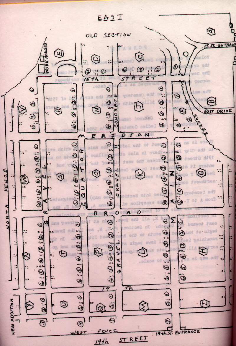
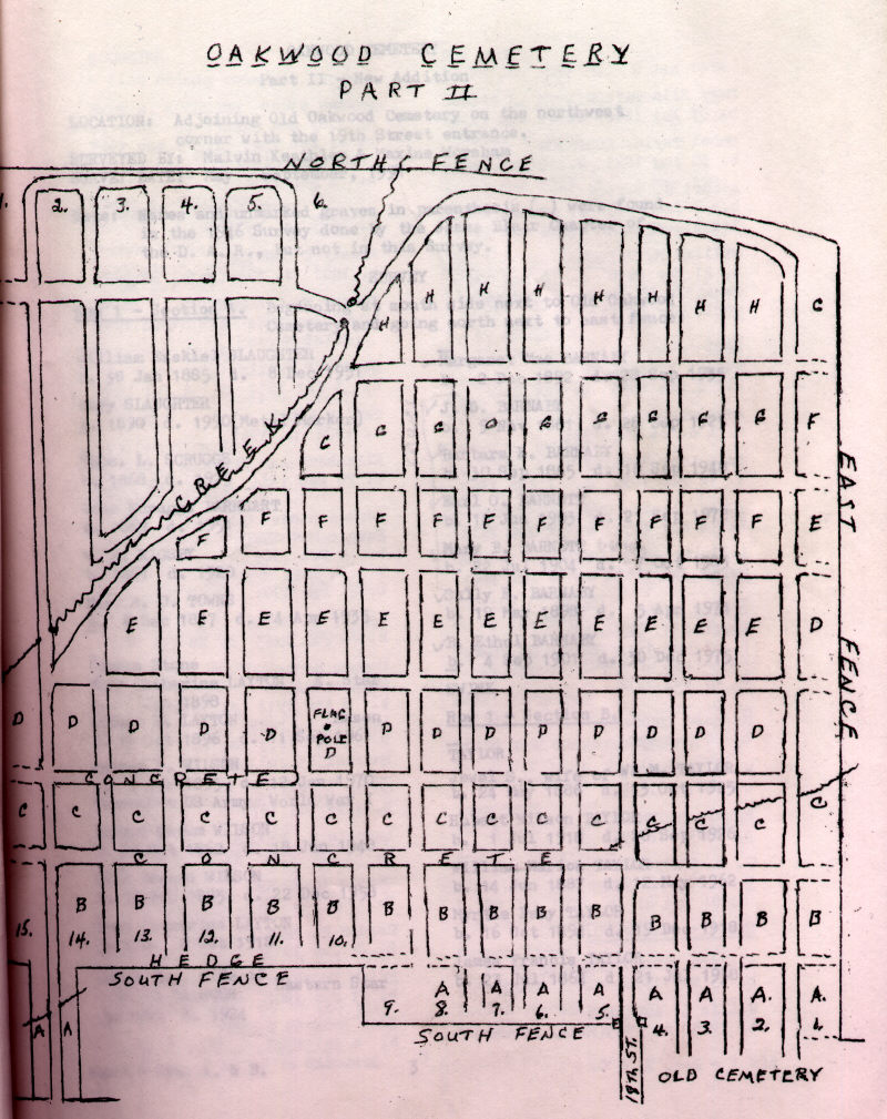
| Oakwood |
|
9 &
10
|
Corsicana
North end of 15th St
Oakwood Cemetery Maps (Part
I * Part II) |
| Old Chatfield |
|
3
|
One mile north of Chatfield Store, Chatfield |
|
Old
Jones |
|
|
See:
Antioch Hardshell Baptist |
|
Old Pursley |
36
|
|
Fifteen miles SW Corsicana FM Rd 709, so on FM 642, East 1/2 mi. |
|
Original French |
|
3
|
.7
mi North of Navarro Mills Plant on FM Rd 667 East of 667 in pasture
Cemetery Surveyed at
www.findagave.com |
| Owen-Waters Family (Inactive) |
|
1
|
Left
of FM Rd 1393 before reaching Chambers Creek bridge, south of Kerens. |
| Owen Family (Inactive) |
|
7
|
S.W.
of Kerens, off left of FM Rd. 2859 before reaching Chambers
Creek.
Survey: Also Published in
Navarro Leaves & Branches Vol 6, Issue 2, May 1983.
|
| Pattison |
6
|
3
|
One mile west of Emhouse, TX off FM Rd 1126
MAP
|
| Pelham Community
(Black) |
|
7
|
Approx. 1 mile south
east of Pelham, which is on FM Rd. 744 2 miles west of
Emmett |
|
Petersburg (Black) |
|
3
|
Also known as Round Prairie Community Cemetery; Ten miles south of Kerens
off FM Rd 309. |
| Petty Family
(Inactive) |
17-b
|
1
|
In Corsicana 250 yards south of Overpass on Hardy Avenue
adjacent to railroad |
| Petty's Chapel |
17-a
|
3
|
Back
of Petty's Chapel Church on Corsicana - Roane Rd
|
| Pevehouse |
|
1
|
Three miles south east of Frost, 1/2 mile east FM road
667 |
| Pevehouse (Old) |
|
1
|
A mile or so east of Frost
three miles SW of Blooming
Grove. Inactive for many years. |
| Pisgah Ridge see (David
White) |
|
|
|
| Pleasant
Hall
(Black-Freestone Co.) |
|
1
|
Near Winkler,
Freestone County, Texas
MAP |
| P3
Porter Ranch Family Cemetery |
|
|
P3 Porter Ranch near Pelham, Navarro Co., TX |
| Post Oak |
17
|
1
|
One mile west of Roane |
| Prairie
Grove |
11
|
2
|
Next to Prairie Grove Church, Emmett Texas |
| Prairie Point |
23
|
6
|
One and a half miles north east of Bazette |
|
Princeton (Black) |
|
8
|
At
intersection of FM Rd 309 & Hwy 287 take dirt road east past cross
roads and fist right turn to dead end. |
|
Providence (Mildred) |
31
|
7
|
Hwy
287, past Mildred, third turn off Road to right.
|
|
Providence (Black) |
|
3
|
Out N. North
Beaton St. to the right., Corsicana |
Pruitt Cemetery
aka
Blanford - Gowan - Majors |
|
8 |
One mile east of Blooming
Grove, turn left on gravel road, keep right at
fork, go approx 2 mi. Cemetery is off to left in a tall cedar thicket
behind a corrugated tin barn. On Private Property |
|
Pursley (Old) |
27
|
3
|
|
|
Pursley (New) |
|
3
|
|
|
Raleigh |
|
1
|
Fifteen and one half miles west of Corsicana
FM Rd 744 and south off 744 1/2 mile |
| Red Cemetery (Freestone
Co.) |
|
1
|
Wortham, Freestone County TX |
| Resthaven |
|
|
Corsicana, TX |
| Rice |
4
|
4
|
1.4 miles north east of Rice
|
| Rice (Black) |
|
4
|
1 1/2
miles south of Rice off east of I-45 |
Richland
(at Richland) |
38
|
|
Richland |
| Richland (at Mertens,
Hill Co) |
8
|
6
|
|
|
Robinson Cemetery |
|
|
Chatfield, TX |
| Rose Hill |
5
|
7
|
Western edge of Blooming
Grove, TX south off Hwy 22.
Complete List of Burials in Microsoft Excel Format (Part 1 ||
Part 2) Submitted by Diane Richards |
Round
Prairie
See: Long Prairie |
34
|
|
Kerens, TX |
|
Rural Shade (Inactive) |
|
3
|
East
of FM Rd 309 between Hwy 287 & Kerens |
| Salem (Hill Co.) |
48
|
|
Location: Hill
Co. just west of Emmett
|
|
Samaria (Black) |
|
8
|
North of the Samara Community which is 5 miles S.E. of Kerens
on FM Rd
3096. |
Silent Grove Cemetery
See Cheneyboro Cemetery |
|
|
Cheneyboro, TX |
|
Sloan |
|
6
|
At Powell, TX, turn so. from Hwy #31 to FM Rd 633. Go south 2
miles to Elm Flat Community; turn west on gravel Rd; go 1/2 mi to 3/4 mi.
About 200 ft north
in a pasture. |
| Spring Hill |
|
3
|
Location: 3 miles N. of
Cemetery sign, 1 mile E. of Dawson,
TX
Link to:
USGenWeb Extract |
| St. Elmo (Winkler,
Freestone Co.) |
42
|
1
|
Winkler,
Freestone County, TX |
St. John's Episcopal
Church
Columbarium |
|
|
Corsicana, TX |
|
State Orphans Home Cemetery |
|
|
Corsicana, TX |
|
Sweatmon Cemetery |
|
|
Navarro County, TX |
| Swink Cemetery |
|
|
|
|
Thomas Mooney Cemetery |
|
|
Single Person
Burial Site |
|
Thompson Family Cemetery |
|
|
Brushie Prairie |
|
Timothy Community Cemetery (Black) |
|
3
|
1.3
miles south off FM Rd 1129, near Trinity River |
Tolliver Cemetery
(Inactive-Black) |
|
8
|
Friendship Community, off FM Rd 3096 halfway between Kerens &
Samaria on corner of dirt Road. Info from Bill Yong |
| Union High - AKA Boardtree |
|
|
|
| Union Hill (Black) |
|
1
|
Approximately six miles south west of Frost, near Hill
County line. |
| Unnamed |
|
1
|
Across the road from Union Hill Cemetery, Approximately
six miles south west of Frost |
|
Ward |
28
|
3
|
Off
FM Rd 709 10 miles SW of Corsicana |
| Wesley's Chapel |
|
1 & 3
|
Northeast of Powell |
White Cemetery
aka Pisgah Ridge Cemetery or (David
White) |
|
|
|
|
Whitehead (Inactive) |
|
6
|
Three miles south of Richland on Hwy 14. turn right .2
miles left in pasture. |
| White Chapel |
|
|
aka Jimmerson or White Church
Located in Navarro County Texas, Approx. 1/2 mi east off dirt road between
Goodlow, south of
Kerens, and FM Road 1393, near
Rush Creek |
| White Church |
|
4
|
One & 1/4 miles
south east of Blooming
Grove. |
|
Williams Cemetery in Frost |
|
|
About 2 miles Southeast
of Frost;
North side of NWCR 4050 about 1/4
East of the intersection of NWCR 4050 and NWCR 4090 |
|
Woodland |
|
11
|
East
side of Corsicana, on North Burnet Street |
|
Woods (Black) |
|
8
|
FM Rd 633 go south from
Kerens,
through the Elm Flat Community, take
right turn south on dirt road which dead ends 1/2 mile at Cemetery |
| Younger |
19
|
1
|
Off
Highway 31 just west of Silver City
Link to: USGenWeb - Younger Cemetery Survey |
| Zion's
Rest |
16
|
3
|
North Beaton St. in Corsicana past North park
Formerly Duncan Cemetery
|