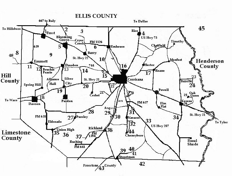
Cemetery Map
Navarro County, Texas


HOME


Map Index || Cemetery Index


cem_map.jpg (110630 bytes)

34 Alligator (Long Prairie)
  Bardwell (Near Ennis - Ennis County)
24 Bazette
39 Birdston (Thru Streetman to old Hay-Lift at 1364 to Winkler) (Navarro County)
10 Black Hills
35 Board Tree (At Union High)
12 Brushie Prairie
41 Burton
43 Cade (Freestone County)
14 Campbell - Elrod (At Drane) (On FM 744)
7 Chatfield
44 Cheneyboro
21 Cosgrove
5-A Cryer Creek
15 Cunningham
18 Dawson (West End of 3rd St.)
13 Dresden
16 Duncan (Now Zion's Rest)
11 Prairie Grove (Emmett)
33 Eureka
1 Frost
3 Grange Hall
30 Grape Creek
22 Hamilton-Beeman
32 Hopewell (at Navarro)
26 Kerens
45 King (Aley) (Henderson County)
2 Lone Oak
34 Long Prairie (See Alligator Cemetery)
29 Love
  Mankin (Henderson County) (Turn Left at Trinidad)
20 Marshall
40 Midway
25 Oak Grove (Near Kerens)
16 Oakwood
36 Old Pursley
37 Pisgah Ridge - David White Cemetery
6 Pattison Cemetery
17 - A Petty's Chapel
17 - B Petty's Chapel Cemetery (At Bridge on Hardy)
17 Post Oak
23 Prairie Point
31 Providence (Mildred)
27 Pursley
4 Rice
38 Richland (At Richland)
8 Richland (At Mertens) (Hill County)
5 Rose Hill (Blooming Grove)
34 Round Prairie (See Alligator)
42 St. Elmo (Winkler) (Freestone County)
28 Ward
9 White Church - Blooming Grove
19 Younger
16 Zion's Rest (Was Duncan)
48 Salem (Hill County)

Navarro County TXGenWeb
© Copyright March, 2009
Edward L. Williams & Barbara Knox